• Skip to primary navigation
  • Skip to main content
  • Home
  • Events
  • Museum
    • Stages of Development
    • Exhibits
    • OCHS Gift Shop
    • Donate Items To The Collections
  • Research
    • Library and Archival Holdings
    • Family Names of Ocean County
    • Families of Old Dover – Booklets
    • Research Center Donation
  • Bookstore
    • Books by OCHS
    • Books by Other Publishers
    • Maps
    • Other Items
    • Shopping Cart
  • About
    • Hours & Visiting
    • Our Board of Trustees and our Officers
    • Contributions
    • Contact Us
    • Social Media
      • YouTube
      • Facebook
      • Instagram
      • Twitter
  • Support
    • Membership
    • Volunteers
    • Internships
      • Community Service Information
      • Undergraduate Internship Program
      • Graduate Internship Program
  • Donate
    • Tribute and Estate Gifts
    • Annual Appeal
    • Research Center Donation
Ocean County Historical Society Logo

1850 New Jersey by Robert Horner – Large Map

December 23, 2021 By

$25.00

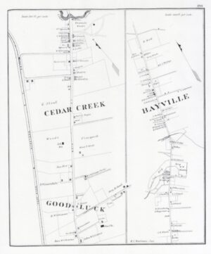
1850 New Jersey by Robert Horner:  This map shows the Cranberry Inlet closed, Dillons Island (now Island Heights), the Toms River, Forked River Mountains and many creeks.  Cedar Creek was called Williamsburg and Manasquan is shown as Howell Township.  25″ x 40″

Category: Maps

Related products

  • Lavallette City By The Sea Squan Beach, Ocean County, NJ – Large Map

    $15.00
    Add to cart
  • Toms River – map

    $5.00
    Add to cart
  • Cedar Creek, Bayville, Good Luck – map

    $5.00
    Add to cart
  • Manahawkin – map

    $5.00
    Add to cart

Discover More About Ocean County

Browse our online bookstore for historical maps, audio/visual media, and books, such as "Shore Chronicles" and "Place Names of Ocean County" - just two of the many fascinating stories about Ocean County.
Shop Now

Ocean County Historical Society 26 Hadley Avenue Toms River, NJ 08753 (732) 341.1880 Contact

© 2023 Ocean County Historical Society. All rights reserved.    Privacy / Admin